FoodScapes Food Atlas
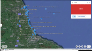
The FoodScapes project looks at different food types and their history in the region. For each of the 8 maps, there are 10 points located on each map. The first point describes the history and the last point talks about the future of that food type. The remaining 8 points give history about that food category in a particular location. The different food categories include drinks, salt, fish amongst others. The FoodScapes Food atlas is accessed via Google Earth and shows the location of the category item.
FoodScapes Atlas User Guide
The FoodScapes Atlas is a digital, shareable, map with slideshow and text, presenting spatially-referenced stories of food in the Tyne-Tees seascape. The Atlas was written and compiled by Prof. Maggie Roe and Dr Maria Duggan of the School of Architecture, Planning and Landscape and the Centre for Landscape at Newcastle University, and is an output of the FoodScapes Project, part of the SeaScapes Landscape Partnership Project (Tyne to Tees, Shore and Seas). The link for the user guide for Food Atlas can be found here.

- You can access the Atlas online here:
- You can also find the link by searching online for ‘Centre for Landscape Newcastle University’ and looking at the page for ‘News’.
- The Atlas will open in Google Earth online if you open the link from a desktop computer. Click on the ‘Table of Contents’ in the bottom left corner to open the Atlas and use the arrows to move through the slides. If you accidentally come out of the Slideshow, click the three vertical dots next to ‘FoodScapes Atlas’ and then press ‘Start Slideshow’. You can use a mouse to scroll down through the story or click on any ‘find out more’ links
- If you open the link or use the QR code from a mobile phone or tablet you will be prompted to download or open the free Google Earth app. This app might not be supported on all phones or tablets. Click on the ‘Table of Contents’ at the bottom and use the arrows to move through the Slideshow. If you accidentally come out of the Slideshow click the three horizontal dots next to ‘FoodScapes Atlas’ and then press ‘Start Slideshow’. Use your finger to scroll down through the story or click on any ‘find out more’ links
The FoodScapes Atlas is free to use and we hope you enjoy reading the stories. Please share the link. We would be keen to hear about how it is being used – you can email maria.duggan@ncl.ac.uk


